
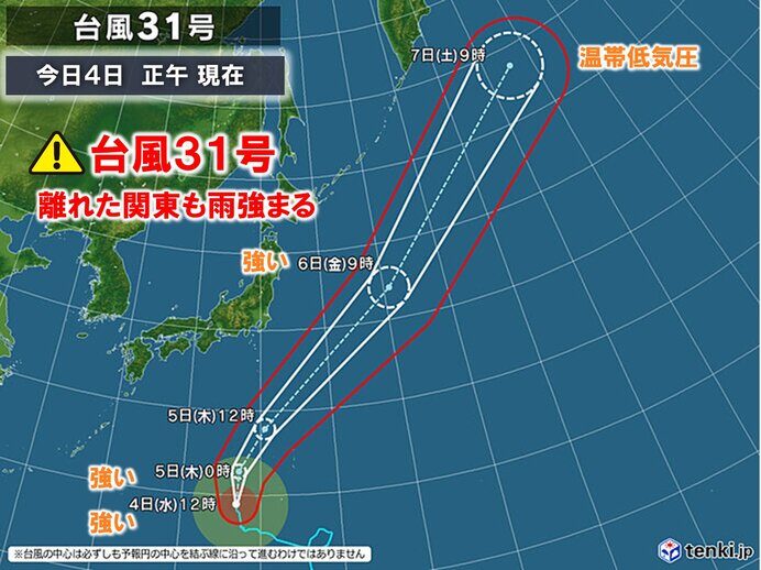
Strong Typhoon In-fa (Typhoon No. 31) is forecast to approach the Ogasawara islands with its storm zone on Thursday, the Japan Weather Association reported. The same system is expected to help drive warning-level rain into the Kanto region from Wednesday night into Thursday morning, with the peak likely to land on the commute.
At noon on Wednesday the typhoon was south of Japan, moving slowly north with a central pressure of 970 hectopascals. It is expected to turn further north and near the Ogasawara islands on Thursday. Forecasters expect it to have weakened from "strong" status by the time it arrives, but warn that violent winds and high waves will still pose a danger.
The islands lie roughly 1,000 kilometers south of Tokyo and are reachable mainly by a scheduled ferry that runs about once a week, which leaves residents little margin to leave ahead of a storm. The association urged people there to watch for strengthening wind and waves and to check the latest typhoon information.
Rain peak to hit Kanto on Thursday morning
The typhoon itself is expected to track northeast over the sea east of Japan and to have no direct effect on land. But a low-pressure system is forecast to form off the Boso Peninsula by Thursday morning and move northeast along the Kanto coast as it develops. Warm, humid air circulating around the typhoon will feed into that low, making the atmosphere highly unstable across the Kanto-Koshin region.
From late Wednesday night until shortly before noon on Thursday, some areas of Kanto are expected to see heavy rain with thunder, in places extremely heavy. Hourly rainfall on Thursday is forecast to reach 40 millimeters in northern and southern Kanto and 50 millimeters in the Izu islands. Over the 24 hours from 6 a.m. Wednesday, southern Kanto could see 100 millimeters and the Izu islands 120 millimeters.
If rain clouds grow stronger than expected or keep passing over the same areas, the rain could reach warning level, the association said. The morning peak may overlap with the commute to work and school, and residents are advised to watch for flooded roads, inundated low-lying land, swollen rivers and landslides, as well as lightning, tornadoes and hail.
On Friday the typhoon is expected to regain strong intensity and accelerate northeast over the sea east of Japan, becoming an extratropical cyclone east of the Kuril islands on Saturday. This is the first year in 13 that typhoons have been numbered as high as 31, and this season's storms are still having an effect into November.